


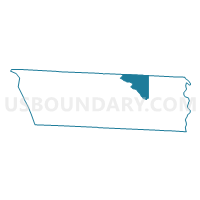
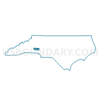
Voting District PC22, Lincoln County, North Carolina
About
Outline

Summary
| Unique Area Identifier | 640638 |
| Name | Voting District PC22 |
| County | Lincoln County |
| State | North Carolina |
| Area (square miles) | 13.11 |
| Land Area (square miles) | 13.08 |
| Water Area (square miles) | 0.04 |
| % of Land Area | 99.72 |
| % of Water Area | 0.28 |
| Latitude of the Internal Point | 35.53406330 |
| Longtitude of the Internal Point | -81.10813530 |
Maps

Graphs
Select a template below for downloading or customizing gragh for Voting District PC22, Lincoln County, North Carolina


Neighbors
Neighoring Voting District (by Name) Neighboring Voting District on the Map
- Voting District 09, Catawba County, NC
- Voting District 31, Catawba County, NC
- Voting District BS26, Lincoln County, NC
- Voting District DW28, Lincoln County, NC
- Voting District OB21, Lincoln County, NC
Top 10 Neighboring County Subdivision (by Population) Neighboring County Subdivision on the Map
- Catawba Springs township, Lincoln County, NC (22,548)
- Ironton township, Lincoln County, NC (20,744)
- Mountain Creek township, Catawba County, NC (9,678)
- Caldwell township, Catawba County, NC (7,722)
Top 10 Neighboring Unified School District (by Population) Neighboring Unified School District on the Map
Top 10 Neighboring State Legislative District Lower Chamber (by Population) Neighboring State Legislative District Lower Chamber on the Map
Top 10 Neighboring State Legislative District Upper Chamber (by Population) Neighboring State Legislative District Upper Chamber on the Map
Top 10 Neighboring 111th Congressional District (by Population) Neighboring 111th Congressional District on the Map
Top 10 Neighboring Census Tract (by Population) Neighboring Census Tract on the Map
- Census Tract 709.02, Lincoln County, NC (6,338)
- Census Tract 116.02, Catawba County, NC (5,546)
- Census Tract 711.01, Lincoln County, NC (5,315)
- Census Tract 709.01, Lincoln County, NC (3,159)